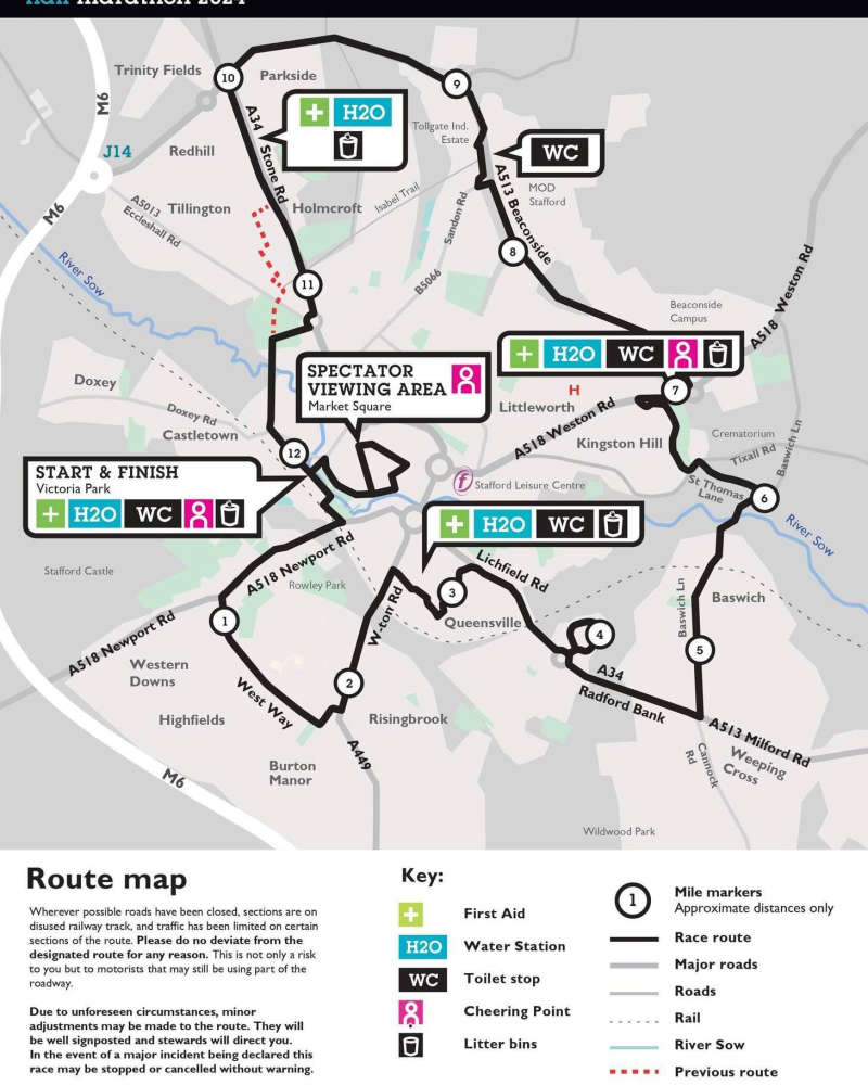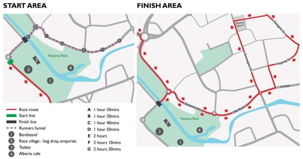
There are a small number of road closures in place for today's Stafford Half.
It's the 40th anniversary of the Stafford Half Marathon with some road closures set to kick in after 10am on Sunday 17th March.
Some tweaks have been made to the last 3 miles of the planned course due to flooding and the potential of flooding. This has meant that the route has been slightly amended. 
Staffordshire County Council is implementing a number of road closures to co-incide with the event;
These are the roads that will be closed between 7am and 3.30pm:
- Eastgate Street (from Cope Street to Salter Street)
- Greengate Street (from Crabberry Street to South Walls)
- South Walls (from Greengate Street to Greengate Walk)
- Tenterbanks A5187 (from Broadeye roundabout to Victoria Road)
- Mill Street (from Greengate Street for approximately 73m in an easterly direction)
- South Street (from Victoria Road for approximately 93m in a north-westerly direction)
- Lichfield Road A518 (from Queensway Island gyratory for approximately 61m in a north-westerly direction)
- Kingsway A5288 (from the roundabout with Redgrave Drive to Newport Road)
- Newport Road A518 (from West Way to Bridge Street)
- St Leonard’s Avenue (at the junction with Lichfield Road)
- Queensville Avenue (at the junction with Lichfield Road)
- Baswich Lane (from Weeping Cross to Audlem Road)
- Weston Road A518 (at the roundabout with Hydrant Way)
- Portal Road (at the junction with Beaconside)
- Sandon Road (at the junction with Beaconside)
- Stone Road A34 (southbound from the Redhill roundabout to the junction with Holmcroft Road and northbound from Greyfriars roundabout to the junction with Holmcroft Road)
- Holmcroft Road (from First Avenue to Stone Road)
- Tipping Street
- Water Street
- Victoria Road
- St Thomas Lane

The following roads are on the event route or are associated streets:
- Victoria Road A5187
- Station Road A5187
- Newport Road A518
- West Way, Rising Brook A449
- Rowley Bank A449
- Park Crescent A449
- Wolverhampton Road A449
- Meyrick Road
- Salt Road
- Salt Avenue,
- Abberley Grove
- RanshawDrive
- Lichfield Road A34
- Queensville Bridge A34
- Queensville A34
- Ampleforth Drive
- Link Footway Between 2 To 18 Ampleforth Drive
- Radford Bank
- Baswich Lane
- St Thomas Lane
- Tixall Road
- Wolseley Road
- Birkdale Drive
- Longhurst Drive
- Weston Road A518
- Beaconside A513
- Sandon Road
- The Haybarn
- Tollgate Farm Access
- StoneRoad A34
- Holmcroft Road
- Young Avenue
- Charles Cotton Street
- Pitt Street
- Alliance Street
- Izaak Walton Street
- Link Footway From Izaak Walton Street To Isabel Trail
- The Isabel Trail
- Timberfields Road
- Doxey Road A5288
- North Castle Street
- South Street
- Cycleway From Doxey Road To Izaak Walton Walk
- Izaak Walton Walk
- Link Footway from Newport Road to Mill Bank Via Meadow Bridge
- Mill Bank
- South Walls
- Greengate Walk
- Tipping Street
- Eastgate Street
- Market Street
- Greengate Street
- Tenterbanks A5187.


 Local teams in play-off action this weekend
 North Midlands Hand Centre at UHNM reaches two thousand patient milestone
 Bumper crowd expected for derby day
 Stock up this Easter and avoid the bank holiday rush
 Gatehouse Panto bags national award